
Guides / Nor’easters
What is the 40/70 benchmark?
The 40/70 benchmark is the point at 40° north latitude and 70° west longitude, in the Atlantic about 90 miles south of Nantucket, Massachusetts. East Coast forecasters use it as a yardstick for where a nor’easter’s low-pressure center is passing, which helps show who gets snow, who gets rain and who gets a mix. It is a rule of thumb for track, never a guarantee of snow.
By Weather Decision Solutions. Published . Updated .
It is also where 4070 gets its name. The origin story is on our name page. Here is what the point does for a forecast.
First, what is a nor’easter?
The National Weather Service describes a nor’easter as a storm along the East Coast of North America, named for the northeast winds over the coast. Nor’easters are most frequent from September to April, usually form between Georgia and New Jersey, move northeast, and nearly always bring heavy rain or snow. The same storm can bring rain to one town and a foot of snow to another. Much of nor’easter forecasting is working out which side of the line you land on, and the track is the biggest piece of that.
What the benchmark does for a forecast
Forecasters need a fixed place to measure a storm track against. NOAA’s Weather Prediction Center uses the point this way in its storm reviews. In its review of the February 6 to 9, 2025 storm, it describes the low passing near the 40N/70W benchmark as it moved east across the Atlantic. The point gives everyone the same ruler.
The ruler is useful because track and temperature are linked. The NWS office in State College, Pennsylvania notes that in a nor’easter the heaviest snow falls north and west of the low’s track, that a fairly consistent line separates rain, mixed precipitation and snow and moves along with the storm, and that rain and mixed precipitation come when warmer air from the ocean is pulled in. Move the track and you move the line.
Where you live changes what a good track looks like. The NWS office in Burlington, Vermont wrote, in its summary of the December 31, 2007 storm, that the heaviest snowfalls for Vermont and northern New York occur when a surface low travels north and west of the 40N/70W benchmark, preferably between Cape Cod and Boston. The low in that storm traveled near the benchmark early that Monday morning before moving into the Gulf of Maine.
| Track | What it tends to do | What else decides it |
|---|---|---|
| West of the benchmark, closer to the coast ("inside") | Pulls warmer ocean air onto the coast and moves the rain-snow line inland. The heaviest snow falls north and west of the track, in the interior. | How cold the air was before the storm, and how far the warm air gets. |
| Near the benchmark | The reference case that forecasters compare other tracks against. Snow versus rain on the coast depends heavily on the air that is already in place. | Storm strength and speed, and the temperature profile. |
| East of the benchmark, farther offshore ("outside") | Keeps the strongest part of the storm offshore, so many places see less precipitation. | How far east it goes, and whether the storm’s western edge reaches land. |
Why it is not a law
A track near the benchmark can still miss on snow, and a track away from it can still deliver. The benchmark knows nothing about:
- how cold the air was before the storm arrived,
- how strong the storm gets and how fast it moves,
- the storm’s internal structure, such as snow bands or a dry slot,
- elevation, coastline and the temperature of the ocean water nearby.
The NWS State College page also warns that timing precipitation changes is very difficult because the low track is uncertain. Forecasters watch the benchmark, then everything else.
What is a bomb cyclone?
A bomb cyclone is a storm that strengthens very quickly. NOAA’s National Ocean Service defines it as a pressure drop of at least 24 millibars in 24 hours at 60 degrees latitude, and about 17.8 millibars at the latitude of New York City. The term describes how fast the storm deepens, not how much snow it brings.
A famous example
The Blizzard of 1996 is one of the best-documented East Coast snowstorms. NWS Heritage describes it as forming in the Gulf of Mexico on January 6, reaching the Georgia coast on January 7 and waters off southern New England on the evening of January 8. Philadelphia recorded 30.7 inches of snow, Newark 27.8, Providence 24.0 and New York City 20.2. NWS Heritage also notes that the European model showed a more northwestern track than the other models, and that the GFS, which started much farther southeast, trended northwest toward an I-95 corridor impact. A shift like that in the track is the whole story of a nor’easter forecast.
How forecasters judge a track with models
Nobody gets to wait for the storm to cross the benchmark and then decide. Days earlier, forecasters look at several models and ask where each one puts the low.
- Different models, different tracks. Models are built differently, so they can place the same storm in different spots. Agreement is encouraging. Disagreement is information too.
- Ensembles show the spread. WPC’s ensemble training notes that where members cluster tightly, predictability is higher. Tracks bunched near the benchmark are a consistent story. Tracks fanning from the coast to well offshore mean your forecast is still open.
- One run is one run. A single run can flip from inside to outside from one cycle to the next. Forecasters compare recent runs to see whether the track is settling or bouncing.
- Compare at the same valid time, so both models show the same hour of the storm.
None of this says which model will be right. It says how much confidence to put in the track. Our guides on ensembles and reading weather models go through the pieces.
How to follow a storm’s track in 4070
4070 has two tools built for this part of the ritual, both part of 4070 Pro.
- Storm Tracks follows developing lows through the GEFS and ECMWF ensembles and the four most recent runs of GFS, GFS AI, Euro, Euro AI and HRRR, with agreement, spread and central pressure. The paths show model support, not a probability and not impacts.
- Model Explorer and Compare Models. Model Explorer lets you choose a model, a field, a run and a forecast hour. Compare Models puts two compatible models side by side at the same valid time, and Compare Cycles does the same for an earlier and a newer run of one model.
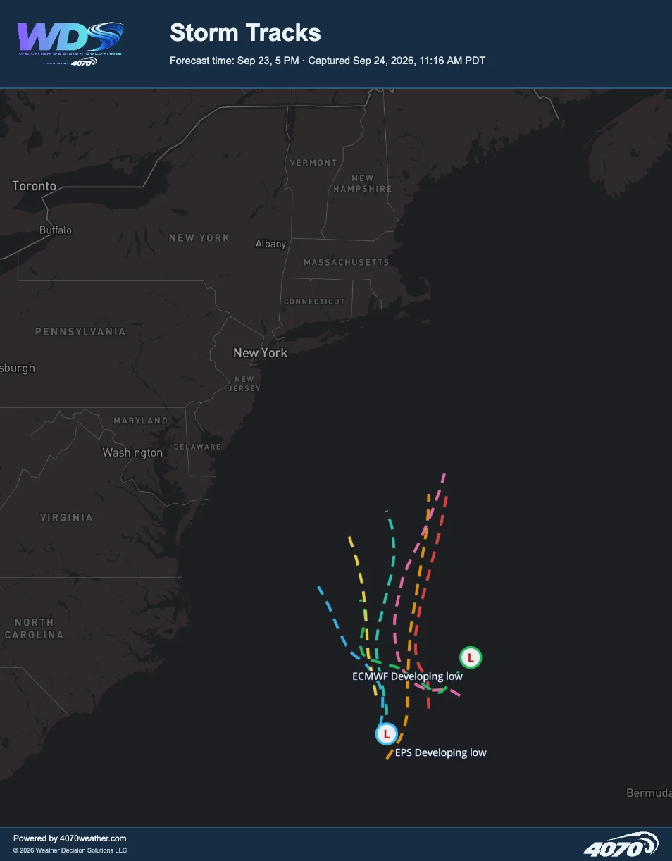
National Weather Service forecasts, watches and warnings remain the authority for what is expected where you live. 4070 shows the guidance behind them. See what is included on the 4070 Pro page.
Common questions
What is the 40/70 benchmark?
It is the point at 40° north, 70° west, in the Atlantic about 90 miles south of Nantucket, Massachusetts. Forecasters judge a coastal low’s track against it when talking about snow and rain in the Northeast.
What is a nor’easter?
A nor’easter is a storm along the East Coast with winds over the coast that are typically from the northeast. The National Weather Service says nor’easters are most frequent from September to April and nearly always bring heavy rain or snow.
Does a track over the benchmark guarantee a snowstorm?
No. It is a rule of thumb for the track. Snowfall also depends on how cold the air is, how strong the storm gets, how fast it moves and its structure.
What is a bomb cyclone?
A bomb cyclone is a storm that strengthens very quickly. NOAA defines it as a pressure drop of at least 24 millibars in 24 hours at 60 degrees latitude, and about 17.8 millibars at the latitude of New York City. The term describes how fast the storm deepens, not how much snow it brings.
What is an inside runner or an outside runner?
An inside runner tracks close to the coast, west of the benchmark, and tends to pull in warmer air from the ocean. An outside runner passes east of it and often keeps the strongest part of the storm offshore.
How do I follow a nor’easter’s track?
Look at several models and runs, and watch how closely the ensemble tracks agree. In 4070, Storm Tracks shows model paths, agreement and spread for developing lows, and Compare Models shows two models at the same valid time. For official forecasts and warnings, check the National Weather Service.
Why is it called 4070?
It is named after the benchmark, the point the team watches whenever a nor’easter takes shape. Say it forty seventy. The story is on the name page.
Is 4070 Weather related to the 4070 graphics card?
No. 4070 is a weather platform from Weather Decision Solutions, named for the coordinates 40°N, 70°W.
Sources
- NWS, What is a nor’easter?. Nor’easters usually form between Georgia and New Jersey, move northeast, are most frequent from September to April and nearly always bring heavy rain or snow.
- NOAA WPC, Coast to Coast Winter Storm (February 6-9, 2025) event review. WPC describes the surface low passing near the 40N/70W benchmark as it moved east across the Atlantic.
- NWS State College, Snow storm types. In a nor’easter the heaviest snow falls north and west of the low’s track, a fairly consistent line between rain, mixed precipitation and snow moves along with the storm, and an uncertain track makes the timing of changes very difficult.
- NWS Burlington, December 31st, 2007 snowfall summary. States that the heaviest snowfalls for Vermont and northern New York occur when a surface low travels north and west of the 40N/70W benchmark.
- NOAA National Ocean Service, What is bombogenesis?. A bomb cyclone deepens by at least 24 millibars in 24 hours at 60 degrees latitude, and about 17.8 millibars at the latitude of New York City.
- NWS Heritage, The Blizzard of ’96 in retrospect. The storm formed in the Gulf of Mexico on January 6, 1996, reached the Georgia coast on January 7 and waters off southern New England on the evening of January 8; Philadelphia recorded 30.7 inches and New York City 20.2.
- NOAA WPC, Ensemble training. An ensemble is two or more forecasts verifying at the same time; the high-resolution control is the best member only about 5 to 7 percent of the time; the GFS ensemble mean began to beat the operational GFS for 500 mb heights at about day 3.5; a multi-model ensemble may verify better than one from a single model.
Follow the next storm’s track.
Storm Tracks, Model Explorer and Compare Models are part of 4070 Pro. The name is the benchmark: say it forty seventy. Start with seven days free, then $14.95 a month.