
Models / Explained
The GFS weather model
The GFS, or Global Forecast System, is NOAA’s global weather model. It runs four times a day on a grid of about 13 kilometers and forecasts out to 16 days. It is a deterministic model, which means one run, so it is best read next to its ensemble and next to other models.
By Weather Decision Solutions. Published . Updated .
At a glance
| Item | Detail |
|---|---|
| Produced by | NOAA, through the National Centers for Environmental Prediction (NCEP) and its Environmental Modeling Center |
| Type | Global deterministic model, a single run |
| Grid spacing | About 13 km, with 127 vertical layers, using the FV3 dynamical core |
| Forecast range | 16 days (384 hours) |
| Runs | Four a day: 00Z, 06Z, 12Z and 18Z |
| Current version | GFSv16, implemented March 22, 2021. NOAA has planned the next version, GFSv17, for implementation in the first quarter of fiscal year 2027. |
| New runs in 4070 | 00Z, 06Z, 12Z and 18Z |
What GFS is
The GFS is the American entry in the group of global weather models. It is the model that gives a quick answer for the whole planet: it covers every region, runs on a regular schedule, and has a long record that forecasters have learned to read.
It simulates the atmosphere by dividing it into a three-dimensional grid and stepping forward in time. The grid spacing of about 13 kilometers is fine enough to draw a storm system, a front or a jet stream, but too coarse to draw an individual thunderstorm. For that detail, forecasters switch to a high-resolution regional model such as HRRR.
Because it is deterministic, one GFS run is one possibility. Its companion ensemble, GEFS, runs the same kind of model many times to show how much that possibility can change.
Where it does well
- Global coverage on a fixed schedule, four times a day, with output for 16 days.
- A full set of fields, from pressure and temperature to upper-air winds, so it works for almost any question about the large-scale pattern.
- Long public history. Because the GFS has run in similar form for years, forecasters know its habits, which makes it easier to read than a new model.
- A good tool for reading the setup three to ten days ahead: where the troughs and ridges are, and how storms may track.
Where it falls short
- It is one run. A single GFS map can flip from one cycle to the next, so look at the trend over several runs and at the ensemble.
- A 13 km grid cannot draw individual thunderstorms or narrow snow bands. Treat small-scale features as hints.
- The farther out, the less detail you can trust. A map for day 14 describes a pattern and not a street.
- Snowfall maps built from the GFS often use an assumed snow-to-liquid ratio. A fixed 10:1 map can overstate near-freezing snow and understate very cold snow.
What it is typically used for
- Finding the large-scale pattern and the track of storms several days out.
- Checking when cold air or a warm-up arrives, using 850 mb temperature and thickness.
- Comparing with another global model at the same valid time to see whether the storm story agrees.
- Serving as the starting point for soundings and for model-based point forecasts at a location.
How to see GFS in 4070
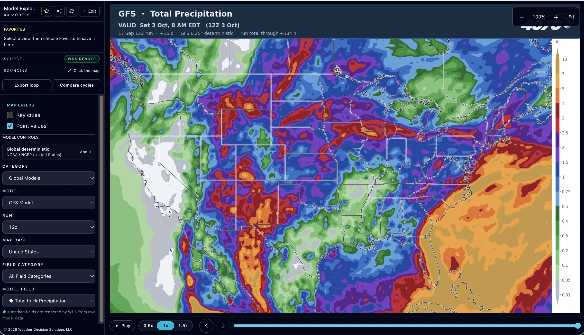
The GFS is in Model Explorer under Global Models, where you choose a field, a run and a forecast hour. Everything below is part of 4070 Pro, which starts with a seven-day free trial.
- Fields include 1 to 60 hour precipitation totals, rate of precipitation, simulated radar, snow depth and a 10:1 total snowfall field drawn by WDS, plus thickness, 850 mb temperature with pressure and precipitation, 10 meter wind and gusts, surface CAPE and CIN, and upper-air maps from 925 to 200 mb including 500 mb heights and wind and 500 mb vorticity.
- Soundings: a supported GFS map lets you click a point and open a forecast sounding with a skew-T and hodograph, and the point stays pinned as you change forecast hour.
- Compare Models puts the GFS beside another compatible model at the same valid time, and Compare Cycles wipes between an earlier and a newer GFS run.
- Plumes overlay the four most recent GFS runs at a U.S. point on a 0.25 degree grid, and Storm Tracks follows the four most recent GFS runs for developing lows.
Learn what the labels mean in how to read weather models.
How it fits with the other models
The GFS and the ECMWF IFS are the two global models most forecasters check first. They are built by different agencies with different methods, so they can place the same storm differently, which is the reason to compare them at the same valid time. NOAA AI-GFS is a newer machine-learning model from the same agency. For details inside a day or two, step down to HRRR. For confidence, step across to GEFS. Our guide on which model is most accurate explains why the best choice depends on the question.
Specifications change when agencies upgrade their models. The Sources below link to the producing agency. Official National Weather Service forecasts, watches and warnings remain the authority for what is expected where you live.
Common questions
What does GFS stand for?
GFS stands for Global Forecast System. It is NOAA’s global weather model, produced by the National Centers for Environmental Prediction.
How often does the GFS run?
Four times a day, at 00Z, 06Z, 12Z and 18Z, with forecasts out to 16 days. In the eastern United States during daylight time those are 8 PM, 2 AM, 8 AM and 2 PM EDT.
What is the resolution of the GFS?
The GFS grid spacing is about 13 kilometers, with 127 vertical layers. That is fine enough to draw storm systems and fronts but too coarse for individual thunderstorms.
Is the GFS or the Euro better?
It depends on the variable, lead time, region and season. They are built by different agencies and can place the same storm differently, so compare them at the same valid time. In 4070, Compare Models shows two models at the same valid time, and Model Scorecard in 4070 Pro shows how the models compared with the nearby weather station at each of your saved locations over recent days.
How far out can the GFS forecast?
The GFS forecasts out to 16 days. Forecasts that far out describe the large-scale pattern, and the details become less reliable the farther out you look.
Where can I see the GFS in 4070?
In Model Explorer under Global Models. Choose a field, run and forecast hour. Soundings, Compare Models, Compare Cycles and Plumes also use the GFS. These tools are part of 4070 Pro, with a seven-day free trial.
Sources
- NCEP EMC, Global Forecast System. GFS runs four times a day to 16 days at about 13 km with the FV3 core; GFSv16 was implemented March 22, 2021.
- ECMWF, Quantifying forecast uncertainty. Every forecast carries uncertainty from the starting state and from model approximations, both growing with time; ensembles estimate it.
- NWS La Crosse, Why snow ratios matter. 10:1 is an old rule of thumb; real snow-to-liquid ratios vary widely, even within one storm, with temperature, cloud makeup and wind among the reasons.
- NOAA WPC, Ensemble training. An ensemble is two or more forecasts verifying at the same time; the high-resolution control is the best member only about 5 to 7 percent of the time; the GFS ensemble mean began to beat the operational GFS for 500 mb heights at about day 3.5; a multi-model ensemble may verify better than one from a single model.
See GFS in 4070.
Model Explorer, Compare Models and Plumes are part of 4070 Pro. Start with seven days free, then $14.95 a month.